Sonoran Desert & Superstition Mountain Tours
The saguaro, the wildlife, the collapsed supervolcano behind the Superstitions, and the heat that kills — everything to know before touring the Sonoran Desert east of Phoenix.
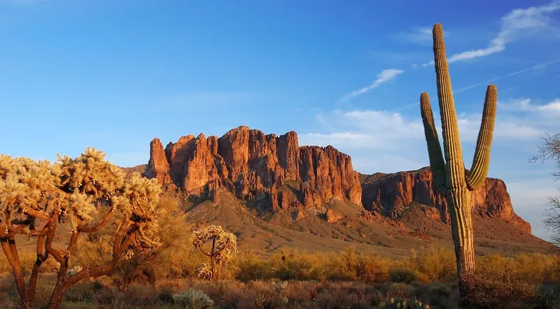
The Sonoran Desert is the most biologically diverse desert in North America, and the stretch of it east of Apache Junction is its lushest corner. That is not tourism copy — it is a consequence of rainfall arriving twice a year instead of once, and it is why the saguaro forest below the Superstition Mountains looks less like a wasteland and more like an overgrown garden that someone forgot to water.
This guide covers what is actually growing and moving out there, the collapsed supervolcano that produced the skyline, what the law permits if you want to drive on it, and the one fact that matters more than all the others put together: the heat here kills hundreds of people a year, and the season you visit in changes everything. Prices and seasonal schedules shift out here too, so confirm current rates before you book anything.
The tour in that calendar is the Apache Trail Histories and Mysteries One Day Van Tour — the one that spends the most time on the natural and human history of this landscape, with a guided desert nature walk, the Superstition Mountain Museum, Weaver’s Needle and Goldfield’s gold mine in a single day. It is new on GetYourGuide with no reviews yet; its operator, Across Arizona Tours, averaged 4.9 from more than 60 reviews on its earlier steamboat day trip.
What Makes the Sonoran Desert Different
The Sonoran Desert spans two U.S. states and three Mexican ones — Arizona, California, Sonora, Baja California and Baja California Sur. The Arizona-Sonora Desert Museum puts it at approximately 100,000 square miles; the Center for Biological Diversity uses 120,000. The difference is boundary-drawing, not disagreement, and the lower figure is the better-sourced one to quote.
It is consistently described by the National Park Service, the World Wildlife Fund and the Desert Museum as the most biologically diverse desert in North America. Botanist Mark Dimmitt’s A Natural History of the Sonoran Desert gives the authoritative numbers: “a rich spectrum of some 2000 species of plants, 550 species of vertebrates, and unknown thousands of invertebrate species.” The NPS counts more than 350 bird species, roughly 100 reptiles, about 60 mammals and around 20 amphibians. The Desert Museum also notes it has the greatest diversity of plant growth forms of any desert on Earth — some seventeen distinct ones.
The engine of all that is bimodal rainfall. Winter brings gentle, widespread frontal rain off the Pacific from roughly December to March. Summer brings the North American Monsoon — violent, localised thunderstorms from about July to mid-September. Two rainy seasons produce two entirely separate floras of annual wildflowers and support far more life than a desert with one. Annual precipitation runs from under 3 inches in the driest subdivisions to roughly 12–15 inches in the wettest.
The Superstitions and Apache Junction sit in the Arizona Upland, the highest, coolest and wettest of the desert’s subdivisions. Its plants have to tolerate winter frost, which sets its flora apart from the lower, warmer country toward the Colorado River. The Arizona Upland is the classic saguaro-and-palo-verde landscape people picture when they picture the Sonoran Desert at all — and roughly 380,000 hectares of Tonto National Forest is exactly this.
How It Compares to the Other Three
North America has four deserts, and confusing them is the most common error in desert writing.
| Desert | Where | Rain pattern | Signature plant | Note |
|---|---|---|---|---|
| Sonoran | S. Arizona, SE California, NW Mexico | Two seasons — winter frontal + summer monsoon | Saguaro, palo verde | Hottest, but also most vegetated and most diverse |
| Mojave | NW of the Sonoran | Mostly winter rain only | Joshua tree, creosote | Drier; the famous 11,700-year-old “King Clone” creosote ring is here, not in the Sonoran |
| Chihuahuan | East, higher elevation | Summer-dominated | Agave, yucca | Few columnar cacti |
| Great Basin | North | Often falls as snow | Sagebrush | A cold desert |
That two-season pattern is the whole story. It is why the Sonoran is the hottest of the four and simultaneously the greenest.
Other Experiences You Might Enjoy
The desert around the Superstitions is a place people come to move through, not just look at: saguaro forest in the Arizona Upland, the volcanic cliffs and spires of the Superstition Mountains, Weaver’s Needle standing over Lost Dutchman country, the red-rock walls of Canyon Lake, the ghost-town streets of Goldfield, and the Tonto National Forest backcountry that guided off-road routes reach and a highway never does. A few more ways to spend a day out here:
The Saguaro, in Depth
The saguaro (Carnegiea gigantea) grows naturally nowhere on Earth except the Sonoran Desert. It is the plant everyone comes to see, and almost everything people believe about it understates how slow it is.
Growth and lifespan. Per Saguaro National Park, a saguaro grows only about 1–1.5 inches in its first eight years. A plant 1–3 inches tall may already be 5–10 years old; at two feet it may be 20–40. It first flowers at about 35 years. Arms normally appear at 50–70 years, and in drier ground it can take up to 100. An adult is generally reckoned at about 125 years old, may weigh 6 tons or more, and can stand 40–50 feet or higher. Average lifespan is roughly 150–175 years and some plants pass 200. The tallest ever measured stood about 78 feet before a 1986 storm took it down. Fully hydrated, a mature saguaro may weigh 3,200–4,800 pounds.
How it drinks. The accordion-like ribs expand as the plant takes up water. Its roots are shallow but wide — a network radiating out roughly as far as the plant is tall — plus a deeper central taproot, which lets it grab rainfall fast before the ground gives it up.
Flowers and fruit. The saguaro blossom is Arizona’s state flower. Blooms appear roughly late April to early June, peaking in May, and each flower opens for less than 24 hours. At night they are pollinated mainly by the lesser long-nosed bat and the Mexican long-tongued bat; by day by bees and by white-winged doves. The fruit ripens bright red in June, each holding around 2,000 tiny black seeds.
Nurse plants and boots. Young saguaros almost always start life in the shade of a “nurse plant” — palo verde, ironwood or mesquite — which buffers them from sun and frost. Gila woodpeckers and gilded flickers cut nest cavities into the trunk; the plant seals the wound with hard scar tissue known as a saguaro boot. Elf owls, purple martins and others move in later. Red-tailed hawks nest up among the arms.
Cultural use. The Tohono O’odham, believed to descend from the Hohokam, have harvested saguaro fruit for centuries — eaten fresh, dried, made into syrup and jam, and fermented into a ceremonial wine tied to calling the rains. The harvest traditionally uses a long pole, the kuipad, made from saguaro ribs, and it marks the beginning of the traditional O’odham new year.
They are dying faster than they were. Recent extreme heat has hit saguaros hard. Desert Botanical Garden research director Kevin Hultine reports that heat and drought have killed roughly 200 of the 1,000 saguaros that once grew on the garden’s 160 acres since 2020. Annual mortality there, “about 1% to 2% prior to the onset of the early 2020s drought,” “soared to 7% in 2023 — Phoenix’s second-hottest year on record — before dropping to a little more than 3%” the following year. Hultine called the trend “not sustainable.” Researchers attribute the collapses to high nighttime temperatures and drought softening the plants’ structural tissue. Notably the Arizona-Sonora Desert Museum near Tucson — higher, and away from the urban heat island — has not seen the same sudden losses, so this is not uniform across the desert.
It is illegal to touch one. The saguaro is protected under Arizona’s native plant law. Destroying or removing one without a permit can bring felony charges, and moving native plants requires permits and tags through the Arizona Department of Agriculture. Invasive grasses — buffelgrass, fountain grass, red brome — are the other major threat, because they carry fire through a landscape that never evolved to burn.
The Rest of the Desert Garden
- Teddy bear cholla and chain-fruit “jumping” cholla. The cholla does not jump. Its barbed stem segments detach at the lightest contact and cling ferociously, which produces the illusion. The dense silvery spines are shade.
- Ocotillo. Not a cactus. It looks like a bundle of thorny dead sticks for most of the year, then leafs out within days of rain and throws crimson flowers that hummingbirds work over.
- Palo verde. Arizona’s state tree, and a classic saguaro nurse plant. Its green bark contains chlorophyll and photosynthesises even after the tree drops its leaves in drought — it keeps making energy while spending almost no water. “Palo verde” is Spanish for green stick.
- Ironwood and mesquite. Legume trees of the washes, both important nurse plants and wildlife food.
- Creosote bush. The source of the famous smell of desert rain. It secretes growth-inhibiting chemicals to keep competitors off its water.
- Brittlebush, barrel cactus, prickly pear, agave, jojoba, desert lavender. All common in the Arizona Upland.
- Spring wildflowers. Mexican gold poppy, lupine, owl clover, desert marigold, brittlebush and globemallow. In the lowlands blooms usually run late February through mid-April, peaking around mid-March, depending on winter rain. Good years need timely, well-spread winter rainfall plus warm days and cool nights.
One myth worth killing: you cannot safely drink water from a barrel cactus. The fluid inside is not stored drinking water — it is alkaline and contains oxalic acid and other compounds that cause nausea, vomiting and diarrhoea, which will dehydrate you faster than the thirst did. Carry water.
Wildlife You’ll Actually See
Mammals. Desert bighorn sheep work the cliffs near Canyon Lake and around Peralta. Javelina travel in family groups and are not pigs — they are peccaries, a separate New World family — and while not generally aggressive they get defensive around dogs or when cornered. Also here: coyote, bobcat, the rarely-seen mountain lion, mule deer, ringtail (Arizona’s state mammal, a nocturnal relative of the raccoon), kangaroo rat (which never drinks, making metabolic water from dry seeds), Harris’s antelope squirrel and black-tailed jackrabbit.
Birds. Cactus wren (the state bird), Gambel’s quail, greater roadrunner, Gila woodpecker, gilded flicker, elf owl, great horned owl, red-tailed hawk, Harris’s hawk (which hunts cooperatively, unusually for a raptor), turkey vulture and bald eagle. Bald eagles nest along Tonto National Forest’s rivers and lakes, and the Forest Service closes breeding areas each year from December 1 to June 30, including a closure area at Goldfield on the Mesa Ranger District.
Reptiles. Western diamondback and other rattlesnakes, Gila monster, desert tortoise, chuckwalla and horned lizard. The Gila monster was the first venomous animal in North America to get legal protection, in 1952; it is illegal to collect, kill or harm one in Arizona. Its bite is painful but bites are extremely rare — it spends about 95% of its life underground and bites almost exclusively when handled. The desert tortoise is protected: if you meet one, do not pick it up. A frightened tortoise may void its stored bladder water and then die of dehydration.
Invertebrates. Tarantula, giant desert centipede, tarantula hawk wasp (whose sting is among the most painful recorded), Africanized honey bees, and the Arizona bark scorpion — the only scorpion in the United States whose venom is medically significant. It fluoresces bright green under UV light and is the best climber of the local scorpions.
If something bites or stings you. For a rattlesnake bite: stay calm, move away from the snake, keep the limb still and at or slightly below heart level, take off rings and watches, and get to a hospital. Do not cut, suck, apply a tourniquet, or ice it. For a scorpion sting: most healthy adults recover at home with wound cleaning, a cold compress and acetaminophen, but children under about 10 and older adults are at higher risk of serious symptoms — muscle twitching, roving eye movements, trouble breathing or swallowing — and need urgent evaluation. FDA-approved antivenom exists. In every case, call the Arizona Poison and Drug Information Center on 1-800-222-1222, free and staffed around the clock.
The Superstitions Are a Collapsed Supervolcano
The range is the deeply eroded remains of the Superstition Cauldron Complex, named by Sheridan in 1978 — a cluster of large volcanic calderas active in the mid-Tertiary. Almost all the exposed rock is volcanic: thick layers of welded and non-welded tuff (fused volcanic ash) and rhyolite lava, erupted from enormous volcanoes that then collapsed into calderas. The Arizona Geological Survey attributes the bulk of it to three major ash-flow tuff eruptions roughly 24.5, 18.4 and 14.9 million years ago, with the range as a whole dated between about 15 and 29 million years. Basin-and-Range faulting and millions of years of erosion did the rest, carving the cliffs, spires and mesas you see now.
Weaver’s Needle is the roughly 1,000-foot column that dominates the interior — an erosional remnant, effectively a volcanic plug left standing as softer rock wore away around it. Its summit is 4,555 feet with about 993 feet of prominence. A split in its side makes it look like it has two tops when seen from certain angles. It is named for the mountain man Pauline Weaver, and it sits at the centre of Lost Dutchman lore — our Arizona ghost town and gold mining guide covers why the geology makes that legend improbable.
Other landmarks worth knowing by name: Flatiron, the prow-like ridge above Siphon Draw; Battleship Mountain; Black Top Mesa; and Miner’s Needle. Two frequent mix-ups: the Praying Monk is on Camelback Mountain, not in the Superstitions, and Four Peaks is a separate range and wilderness to the north.
The Superstition Wilderness covers roughly 160,200 acres inside Tonto National Forest. It was first set aside as a primitive area in 1937–1939, became wilderness under the Wilderness Act of 1964, and reached its current size in 1984. It holds about 180 miles of trails and climbs from Sonoran desertscrub through oak-juniper to pine at the top (Mound Mountain, about 6,266 feet). Group size may not exceed 15 people and 15 head of stock, no motorised or mechanised equipment is allowed — including bicycles — and Leave No Trace practice is required. The Mesa Ranger District administers it.
What’s Legal Where: OHV and Off-Road Rules
Tonto National Forest manages motorised travel through a Motor Vehicle Use Map. Vehicles are allowed only on designated roads and trails, and driving cross-country is prohibited. Designated wilderness, the Superstition Wilderness included, is closed to all motorised and mechanised travel.
- Tonto NF OHV permit. Required for motorised recreation in the Bulldog Canyon, The Rolls, St. Clair and Desert Vista permit zones, bought through Recreation.gov: $10 for 3 days, $60 for 6 months, $80 annual. At least one rider per vehicle must carry the permit in their own name, and under-16s must be with a permitted guardian.
- Tonto Pass. For developed day-use sites along the Salt River and the lakes: $8 per day from vendors, $12 at on-site machines, $80 annual. The $8 pass is sold only at 200-plus Arizona retail vendors, never online.
- Arizona OHV law. An OHV decal is required, machines need working spark arrestors, riders and passengers under 18 must wear helmets, and street use requires a street-legal vehicle.
- Bulldog Canyon is a 34,000-acre permit zone with about 20 miles of full-size routes into the desert and the Goldfield Mountains, with five access points — Blue Point, Usery, Wolverine, Hackamore and Dutchman. The old gate-combination system has been discontinued. There are no lock combinations any more; access simply requires the Tonto NF OHV permit from Recreation.gov, and paper permits are no longer issued at the district office.
Commercial operators need a separate permit. Any company running tours commercially on Forest Service or BLM land must hold a Special Use Permit from the managing agency, and on allocated trail systems the agency caps how many are issued. That is what lets a legitimate operator describe itself as the only authorised outfitter on its permitted trails — the access is allocated, not claimed. Our guide to off-road and Jeep tours near Phoenix and Scottsdale goes through how to check an operator actually holds one, and what the going rates are.
Hiking the Superstitions
Best October through April, and avoid the middle of the day whatever the month.
- Siphon Draw / Flatiron (from Lost Dutchman State Park) — roughly 5.5–6.1 miles round trip with 2,500+ feet of gain to the Flatiron. Strenuous, with steep slickrock and a genuine scramble near the top. Siphon Draw on its own is much easier.
- Treasure Loop (Lost Dutchman State Park) — about 2.4 miles, family-friendly, modest gain, excellent saguaro-and-cliff scenery.
- Peralta Trail to Fremont Saddle — the classic Weaver’s Needle viewpoint. About 4.9 miles round trip, 1,300–1,400 feet of gain, moderate, budget three hours. The big trailhead lot fills early on cool-season weekends.
- Hieroglyphic Canyon — roughly 2.8–3 miles round trip to Hohokam petroglyph panels and seasonal pools. Moderate; very limited parking that fills early.
- Massacre Grounds — 4–5 miles round trip, moderate, with a seasonal waterfall after rain.
- Lost Goldmine Trail — gentler and mostly flat, along the range’s southern base.
- Boulder Canyon and Dutchman’s Trail — longer routes into the wilderness interior.
- Black Mesa Loop — about 9 miles, combining Dutchman’s and Black Mesa.
- Reavis Ranch — a long trek, often 18+ miles round trip depending on trailhead, to a historic ranch site and apple orchard.
Lost Dutchman State Park charges a per-vehicle day-use fee (recently around $10; confirm at azstateparks.com). Peralta and Hieroglyphic fill early — arrive at or before sunrise on weekends. Never touch, chalk or otherwise mark rock art: skin oils damage it and defacing archaeological resources is a federal offence.
Heat, Monsoon, and the Part That Actually Kills People
This is the section that matters most, and it is not scaremongering.
Temperatures. Summer highs in the East Valley run routinely 100–115°F and sometimes higher. Spring and autumn sit in the 70s–90s; winter highs are in the 60s–70s with occasional overnight frost. In 2024 the metro endured a record 113 consecutive days at or above 100°F — May 27 to September 16 — shattering the previous record of 76 days set in 1993, plus a record 61 days at or above 110°F.
Heat mortality. The Maricopa County Department of Public Health confirmed 602 heat-related deaths in 2024, down from a record 645 in 2023, the county’s highest recorded figure. Its April 2026 report identified 430 heat-related deaths in 2025. These are county-wide totals weighted heavily toward vulnerable populations rather than Superstition-specific numbers, but they are the reason search-and-rescue callouts in these mountains spike every warm season.
Water. For active desert hiking, plan on roughly one litre per person per hour, more in extreme heat, plus electrolytes and salty snacks.
Know the difference. Heat exhaustion: heavy sweating, cool clammy skin, weakness, nausea, headache, dizziness — get into shade, cool down, hydrate, rest. Heat stroke is a medical emergency: hot red skin often with no sweating, confusion or altered mental state, rapid pulse, core temperature above about 104°F, possible loss of consciousness. Call 911, move to shade and cool aggressively with water, ice and fanning while you wait.
Monsoon. Roughly July to mid-September brings sudden violent thunderstorms. Washes and canyons flood catastrophically within minutes from rain falling miles away. Never enter a wash or canyon when storms are building, and never drive into moving water.
Why the guided option is the safer summer one. A shaded vehicle with a professional guide, water aboard and a known route carries a fraction of the heat risk of an unsupported hike. Even so, the margins get thin: the Goldfield-based operator Apache Trail Tours suspends its own operations from June 1 through October 14, 2026 for exactly this reason. When a company that makes its living out here closes for four months, that is worth reading as data. Our month-by-month guide has the full seasonal picture, and the road conditions guide covers monsoon closures.
Carry more water than you think you need, sun protection, sturdy footwear, a charged phone, a map and a first-aid kit. Cell service fails across most of this wilderness — do not plan to navigate or summon help with it.
Photography and Dark Skies
Light. The Superstitions face broadly west and northwest from the Apache Junction side, so they light up at sunset. Lost Dutchman State Park is the classic golden-hour position, saguaros in the foreground and the range glowing behind. Canyon Lake and the SR-88 overlooks — Canyon Lake Vista, Fish Creek — give the dramatic water-and-cliff compositions. For Weaver’s Needle itself, the Fremont Saddle viewpoint on the Peralta trail is unmatched, but you have to walk for it.
Dark skies. DarkSky International has certified the Apache Junction Municipal Complex as an Urban Night Sky Place, with dark-sky-friendly lighting at Prospector and Superstition Shadows parks; nearby Fountain Hills is the closest certified International Dark Sky Community to metro Phoenix. Light pollution over Apache Junction itself is moderate — it sits on the metro’s eastern edge — but the sky darkens fast as you head east into Tonto National Forest. Milky Way core season runs roughly late March through October, best on moonless nights. Lost Dutchman State Park occasionally hosts star parties; check the Arizona State Parks calendar.
Whose Land This Is
Human history here starts with the Hohokam (Huhugam), who farmed the Salt and Gila valleys from roughly 1 CE to about 1450 CE and engineered one of North America’s largest pre-industrial irrigation systems — eventually more than 1,000 miles of canals, dug by hand with stone tools and holding gradients of one to two feet per mile. Modern Phoenix canals still follow many of those alignments. “Hohokam” comes from an O’odham word usually translated as “those who are gone”; contemporary O’odham, Hopi and Zuni communities have their own names for these ancestors.
The Akimel O’odham and Tohono O’odham are considered their descendants; the Yavapai and Western Apache also hold deep connections to this landscape. The name Apache Trail comes from the Apache laborers who built the road between roughly 1903 and 1905 to haul materials to the Roosevelt Dam site. The Superstitions carry cultural and spiritual significance in several traditions, and some of that knowledge is culturally sensitive and not ours to repeat or sell.
If you want to go deeper, four sites are open to visitors: Tonto National Monument (Salado cliff dwellings near Roosevelt Lake), Besh-Ba-Gowah in Globe, Casa Grande Ruins National Monument near Coolidge, and the S’edav Va’aki Museum — formerly Pueblo Grande — in Phoenix.
Bottom Line
The desert east of Apache Junction rewards knowing what you are looking at. A saguaro with arms is older than the state of Arizona. The skyline is the wreckage of supervolcanoes that erupted before there were humans to watch. And the same landscape kills hundreds of people a year, almost all of it preventable with water, an early start and a willingness to turn around.
Go between October and April if you can. If you are here in summer, go early, go guided, and stay in the vehicle when the guide says so. Check availability on the featured Apache Trail day tour, compare formats across all Apache Trail tours, or read our self-drive guide if you would rather take your own car as far as the pavement goes.
The Superstitions, Goldfield and a Lake Cruise in One Day
Hotel pickup, a local guide and a group of five or fewer, with Goldfield Ghost Town and a 90-minute cruise on Saguaro Lake. The cruise ticket, about $34, is bought separately after booking, and at least two adults must book. Free cancellation up to 24 hours before.
Check Availability & Book