Driving the Apache Trail Yourself
A self-drive guide to Arizona's SR-88: which sections are paved, what Fish Creek Hill is really like, why rental agreements void on dirt, Tonto Pass fees, and the 2026 dates that change everything.
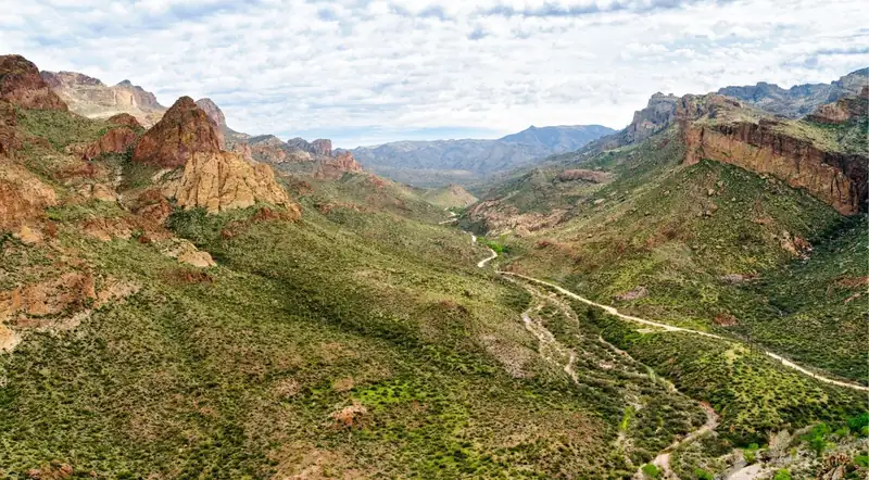
Yes, you can drive the Apache Trail yourself — and as of late August 2026 you can drive all of it. The full ~40-mile stretch of State Route 88 from Apache Junction to Roosevelt Dam is open end to end after ADOT reopened the storm-damaged Roosevelt Dam–to–Fish Creek Hill segment on July 23, 2026. What that sentence hides is that the road is really two roads: an easy paved highway as far as Canyon Lake and Tortilla Flat, and a steep, narrow, cliff-edge primitive road beyond it that has closed for years at a time and that most rental agreements forbid you to touch.
This guide covers what each section actually demands of a vehicle, what it costs to stop, where the fuel and water run out, and the two 2026 closures that will reshape any trip planned for this autumn. One standing caveat before anything else: road status here is a snapshot, not a fact. Re-check az511.gov the morning you drive.
If the unpaved half is off the table for your vehicle — or you’d simply rather look out the window than at the road — the Apache Trail Tour & Canyon Lake Cruise covers the Superstition Mountains, Goldfield Ghost Town and a narrated lake cruise in a single guided day (its itinerary now runs the cruise on Saguaro Lake, outside the Canyon Lake closure), with hotel pickup in Phoenix or Scottsdale. Our full breakdown of that tour has the itinerary and inclusions.
Can You Drive the Apache Trail Right Now? Section by Section
Apache Junction → Canyon Lake → Tortilla Flat (paved, roughly MP 196–213). Fully paved, fully open, suitable for any standard vehicle. Traffic is heavy on weekends and holidays.
Tortilla Flat → Fish Creek Vista (MP 213 to MP 222). Pavement ends around Mile 22 of the drive. What follows is a wide, relatively smooth graded dirt road that Arizona Highways describes as suitable for passenger cars as far as Fish Creek Vista, where there are restrooms and a paved interpretive trail.
Fish Creek Hill / Fish Creek Vista (MP 222) to MP 227 near Reavis Trailhead Road. This is the five-mile section that was closed from 2019 to 2024. The Woodbury Fire of June 2019 grew to 123,875 acres of Tonto National Forest — Arizona’s fifth-largest wildfire on record at the time. A September 2019 storm dropped roughly 6 inches of rain on the burn scar, and the runoff plus a large rockslide left this stretch impassable. ADOT completed a $4 million interim project and reopened it in September 2024, removing boulders on Fish Creek Hill, mitigating rockfall between Fish Creek Vista and Fish Creek Bridge (MP 222–223.5), repairing retaining walls, installing signage, and cleaning or replacing culverts.
About those “4-Wheel Drive Only” signs — the confusion is worth clearing up, because almost every article gets it wrong. Signs installed in 2024 read verbatim: “CAUTION: PRIMITIVE ROAD, No Trailers, 4-Wheel Drive and UTVs Only (Except Authorized Vehicles).” ADOT’s current project page separately states that “there are currently no vehicle restrictions” at Fish Creek Vista. These are not contradictory once you know what each one is doing.
When the section reopened in September 2024, ADOT reopened it restricted — the news release was headlined “SR 88 stretch reopens for high-clearance four-wheel drives,” and the signs went up then. Those signs cover a specific short stretch: milepost 222 (Fish Creek Vista) to milepost 223.5 (the Fish Creek bridge) — the 1.5 miles of Fish Creek Hill itself, not the whole five-mile segment. ADOT’s position now is that no restriction is formally enforced, but the caution signs stay up and the agency’s advice is unchanged: check the forecast, “be confident in their vehicles,” and be comfortable with a stretch that is “steep and more winding and narrow than other parts of SR 88.” ADOT also notes this “can change should severe weather or rockfall affect conditions.”
Read practically: nobody will ticket you for driving a sedan down Fish Creek Hill, and nobody will help you either. The advisory is the honest engineering assessment; the absence of a legal restriction is a paperwork fact. Check az511.gov the morning you drive, and treat the sign posted on the day as the one that counts.
MP 227 → Apache Lake → Roosevelt Dam → the SR-188 junction (MP 229–240+). ADOT reopened 1.7 miles west from Apache Lake Marina to Reavis Trailhead Road in 2022. The stretch from Apache Lake to Roosevelt Dam has been the subject of a separate federal project to pave or chip-seal an 11-mile gravel section. Boaters and anyone towing can always reach Apache Lake from the east via SR-188 without touching Fish Creek Hill at all.
The July 2026 closure and reopening. On July 16–17, 2026, ADOT closed an 18-mile stretch between Tortilla Flat and Roosevelt Dam after a monsoon storm. A gauge near Reavis Trailhead recorded more than 8 inches of rain and one near Fish Creek Hill more than 5 inches, per the Flood Control District of Maricopa County. Crews removed rockfall, cleared culverts and graded the road, and ADOT reopened mileposts 240–222 on July 23, 2026, warning that work continues and drivers should slow through work zones. This is the same failure mode that closed the road for five years. Treat “open” as a snapshot — our Apache Trail road conditions guide explains how to check status yourself before you leave.
The permanent fix is unfunded. ADOT’s own project page notes that an October 2023 study recommended $33.7 million in improvements to make SR-88 more accessible and resilient: chip-sealing all five miles, widening the roadway to 15 feet in steeper areas, increasing drainage capacity, rehabbing bridges and adding pullouts. The study drew comments from nearly 1,700 Arizonans. ADOT states that this “longer-term plan does not have dedicated funding,” and that it is pursuing federal money. Until that changes, the middle section stays a fragile interim primitive road.
The Route, Mile by Mile
- Mile 0 — Apache Junction (elev. ~1,700 ft). SR-88 begins at US-60 (exit 196); Idaho Road becomes the Apache Trail heading northeast.
- ~Mile 4.5 — Goldfield Ghost Town (elev. ~2,000 ft). A reconstructed 1890s mining town at 4650 N. Mammoth Mine Rd. Free to walk the street; the mine tour, narrow-gauge railroad, gunfights and gold panning are paid extras.
- ~Mile 5 — Lost Dutchman State Park. Trailheads into the Superstition Wilderness, a per-vehicle entry fee, and views toward Weaver’s Needle country.
- ~Mile 9 — Canyon Lake Vista / Superstition overlook. Paved pull-off, limited parking, no restrooms or water.
- ~Mile 13–15 — Canyon Lake (elev. ~1,660 ft). Mormon Flat Dam, the two historic one-lane bridges, the marina, the Dolly Steamboat, boating and beaches. A Tonto Pass is required to stop.
- ~Mile 16.5 — Tortilla Flat (elev. ~1,750 ft, pop. 6). The last surviving stagecoach stop on the trail: saloon, general store, restrooms, food, water and gelato.
- ~Mile 18–22 — pavement ends. Graded dirt from here to Fish Creek Vista.
- ~Mile 22 — Fish Creek Vista (MP 222). Restrooms, an interpretive trail, and the last eastbound turnaround before the steep grade.
- ~Mile 22–25 — Fish Creek Hill. The big descent, with Fish Creek Bridge at MP 223.5.
- ~Mile 28 — Apache Lake (elev. ~1,900 ft) and Apache Lake Marina & Resort. Motel, gas, restaurant and bar, store, restrooms — one mile off the highway.
- ~Mile 40 — Roosevelt Dam and the Roosevelt Lake Bridge, then the SR-188 junction.
- ~5 miles up SR-188 — Tonto National Monument, with its Salado cliff dwellings.
Realistic timing. Allow a full day — 7 to 10 hours — for the round trip or the loop with stops. Apache Junction to Tortilla Flat is 45 minutes to an hour without stopping. The unpaved stretch is slow: 15–20 mph, and much less on the grade. A full through-drive to Roosevelt and back over the same road in one day is feasible but long; most people make it a loop instead, which we cover below.
Other Experiences You Might Enjoy
There is more along this corridor than the drive itself. The Superstition Mountains rise over the whole western half of the route, Goldfield Ghost Town sits four miles in on the original 1890s townsite, with a mine tour, a narrow-gauge railroad and staged gunfights, Canyon Lake hides 800-foot red-rock canyon walls and a bighorn sheep population behind the first ridge, Tortilla Flat is a working saloon in a town of six people, and the Tonto National Forest backcountry either side of the highway is open to guided off-road routes that a highway drive never reaches. A few more ways to spend a day out here:
What Fish Creek Hill Is Actually Like
Fish Creek Hill drops roughly 1,000–1,500 feet in about three miles at a 10–17% grade. One detailed trip report cites a “15 to 17 percent grade” with a “1,000 foot drop”; ADOT describes a 1.5-mile section at Fish Creek Vista as “steep and more winding and narrow than other parts of SR 88.” The road narrows to a single lane in places — narrow enough that drivers report folding in their mirrors to pass — with hairpin and blind switchbacks and no guardrails on many curves. Practical speeds on the grade are 5–15 mph. Elsewhere the dirt washboards and ruts, and it gets worse after every rain.
It is worth knowing what “primitive road” means in ADOT’s own terms: an unpaved, minimally engineered dirt roadway, graded but not surfaced, with no shoulders and limited drainage, in a condition that “can change following every rainfall.” ADOT puts it plainly — “today’s roadway may not resemble what you’ll encounter following the next weather event.”
Which Vehicles Can Do Which Sections
- Standard passenger cars and crossovers. Fine to Tortilla Flat, and generally fine on the graded dirt to Fish Creek Vista. Descending Fish Creek Hill in a low sedan is possible in dry conditions for a confident driver, but this is exactly where damage and rental-contract violations happen.
- High-clearance 2WD, AWD, 4WD and UTVs. The intended vehicles for the middle section, per ADOT’s 2024 signage.
- Motorcycles. The ride out to Tortilla Flat is nationally rated a top-ten motorcycle road. The dirt grade beyond is advanced riding.
- RVs, motorhomes, and anything towing a trailer or boat. Do not attempt Fish Creek Hill. The Forest Service posts a maximum vehicle length of 40 feet on SR-88, and the 2024 signs prohibit trailers on the primitive section. RVs and towing vehicles can still reach Canyon Lake and Tortilla Flat on pavement from the west, and Apache Lake via SR-188 from the east.
- Tires, brakes and cooling. Carry a full-size spare — sharp rock cuts sidewalls out here. Use low gear rather than riding the brakes on the long descent, or you will cook them. Watch engine temperature on the hot climbs.
Rental Cars: The Trap That Catches Most Visitors
This is the part almost no trip-planning article tells you, and it is the single most expensive mistake available on this road. Every major agency at Phoenix Sky Harbor restricts or prohibits unpaved-road driving, and a violation typically voids your Loss Damage Waiver and your liability protection.
- Hertz. “Vehicles, including 4-wheel drives, are to be operated only on regularly maintained roads. Off-road use is a violation of the rental agreement.” Hertz’s terms specifically state that vehicles “may not be driven on poorly maintained or unpaved roads.”
- Enterprise, National and Alamo. All prohibit off-road and unpaved-road use. A violation makes the renter responsible for all damage and can void coverage entirely.
- Turo. Off-road use is a Prohibited Use that “will lower your liability coverage to state minimum limits or nullify coverage where allowable by applicable state law.”
- Standard industry language. Contracts warn that a prohibited use “automatically terminates your rental and is an exclusion to and voids all liability protection … including … Loss Damage Waiver.” Tire, wheel and underbody damage are commonly excluded on unpaved roads even where the use itself is tolerated.
The practical conclusion: if you are in an airport rental, drive the paved portion, enjoy Tortilla Flat and the view from Fish Creek Vista, and turn around — or take the paved loop described below. Do not take a rental sedan down Fish Creek Hill. This is the clearest single case where handing the day to a guide is cheaper than the alternative, and we’ve laid out the rest of the trade-offs in our guided tour vs. self-drive comparison.
Permits, Fees, and Where You’ll Actually Pay
- Tonto Pass. Required to park or stop at developed Tonto National Forest sites — the Canyon Lake day-use areas, Apache Lake Marina, Burnt Corral. $8 per vehicle per day at vendors, $12 at on-site machines, $80 annually for the Tonto Discovery Pass. Buy the $8 pass at a gas station or convenience store in Apache Junction; there are no vendors up the road, and the closest fee sites are about 15 miles from town.
- America the Beautiful pass ($80). Covers Tonto day-use standard amenity fees and Tonto National Monument entry — a workable alternative to the Tonto Pass if you already hold one. Note that it does not cover boating.
- Lost Dutchman State Park. A per-vehicle entry fee, reported by third parties at about $10 for one adult or $20 for a full car. Confirm at azstateparks.com before you go.
- Tonto National Monument. $10 per person for ages 16 and up, cashless (credit or debit only). The Lower Cliff Dwelling is open September–May, 8 a.m.–4 p.m., and June–August, 8 a.m.–noon. The Upper Cliff Dwelling is guided-tour-only by reservation, November–April.
- Driving the highway itself is free. You only pay if you stop at a fee site.
Our Canyon Lake visitor guide goes deeper on which Canyon Lake sites need which pass.
Fuel, Food, Water and Cell Service
- Last reliable fuel, ATM, groceries and full cell service: Apache Junction. Fill the tank before you start — this is not negotiable.
- Tortilla Flat. Restaurant and saloon, general store, restrooms, water, gelato. Open daily except Thanksgiving and Christmas, and it has stayed open through every road closure.
- Apache Lake Marina & Resort. Motel, gas station, restaurant and bar, store, restrooms and showers, concessionaire-operated (928-923-6690). Call ahead — the restaurant and bar are not always open.
- Cell coverage. Expect long dead zones on the unpaved stretch. Download offline maps before you leave town.
- Traffic volume. Per ADOT, “before closing in 2019, the stretch between Tortilla Flat and Apache Lake was used by an average of 232 vehicles daily.” On the remote section, help can be a long time coming. Carry extra water, food and a full-size spare.
- If you break down. Call 911 wherever you have signal. The Maricopa County Sheriff’s Office covers search and rescue and lake patrol for this area.
Safety: Monsoon, Heat, and the Things That Go Wrong
Monsoon season, roughly mid-June through September, brings sudden violent thunderstorms, flash flooding and debris flows off the 2019 Woodbury Fire scar. That is the exact mechanism that closed the road in 2019 and again in July 2026. Never enter a flooded wash; the road can become impassable in minutes.
Heat. Summer temperatures routinely exceed 100°F. Carry far more water per person than feels necessary and start early. Tonto National Monument cuts its summer hiking hours to before noon specifically to prevent heat illness — take the hint.
Everything else. Motion sickness is common on the switchbacks. Javelina, mule deer, rattlesnakes and the occasional bighorn are on or near the road. Avoid night driving on the unpaved grade entirely. Rockfall on Fish Creek Hill is an ongoing hazard, not a historic one.
On the road’s reputation. No official, quantified crash, fatality or search-and-rescue statistics exist specifically for Fish Creek Hill. Documented individual incidents include a 2014 fatality in which a car plunged roughly 250 feet off Fish Creek Hill (a second occupant was rescued) and a March 2017 rescue of a minivan about 150 feet down a cliff, both per FOX 10 Phoenix. The danger reputation rests on those anecdotes and on the road’s physical character, not on a published dataset. That is worth saying honestly in both directions: it is not a statistically proven death trap, and it is also not a road to learn mountain driving on.
The History You’re Driving Through
The Apache Trail began as a Native American footpath through the Superstitions. To build Theodore Roosevelt Dam — funded under the 1902 Reclamation Act — the Salt River Valley towns bonded themselves to pay for a haul road. Per the Apache Junction Public Library: “construction of the Tonto Wagon Road began on August 29, 1903, with two hundred Apache laborers working just below the dam site… Another work camp was established on November 11, 1903, at Government Well… employing some 200 Pima laborers. The Tonto Wagon Road was completed on September 3, 1905, at a cost of $551,000.” Apache workers made up the bulk of the labor, and that is where the name comes from. Roosevelt Dam was completed in 1911.
Roosevelt’s own line about the road is still the one everybody quotes: “The Apache Trail combines the grandeur of the Alps, the glory of the Rockies, the magnificence of the Grand Canyon and then adds an indefinable something that none of the others have. To me, it is the most awe-inspiring and most sublimely beautiful panorama nature has ever created.” He also called it “one of the most spectacular, best-worth-seeing sights in the world.”
The Apache Trail Historic Road is one of only four state-designated Historic Roads in Arizona. Two bridges along it are on the National Register of Historic Places: Mormon Flat Bridge (built 1924, listed 1988) and Boulder Creek Bridge (built 1937, listed 1989).
Tortilla Flat, founded in 1904 with a current population of six, is the last surviving stagecoach stop on the trail. Its Superstition Saloon has saddle barstools and walls papered with dollar bills from around the world, bills itself as the world’s largest purveyor of prickly-pear gelato, and serves a chili from a 1940s recipe. Rebuilt after fires and floods, it has operated continuously since 1904.
Goldfield boomed from 1893 to 1898. The historical marker standing at the Bluebird Mine since 1947 puts it plainly: “During its heyday from 1893 to 1898 when $1,000,000 in gold was mined from this area about 300 people dwelt here.” Popular accounts inflate that to 1,500 or even 4,000; the marker is the oldest source and the most conservative one. The vein faulted, the town died, revived briefly as “Youngsberg” between 1910 and 1926, and was largely lost to a 1943 fire before being rebuilt as a tourist attraction from 1984 onward. Our Arizona ghost town and gold mining guide covers Goldfield and the rest of the state’s mining towns in full.
The Lost Dutchman legend. German immigrant Jacob Waltz — “the Dutchman,” despite the name — claimed a rich gold mine in the Superstitions in the 1870s and died in 1891 without revealing its location. Treasure hunters, some of whom have died searching, are still looking, most placing it near Weaver’s Needle.
What You Actually See
Geology. The Superstitions are the eroded remains of a Miocene volcanic caldera complex — at least three collapsed supervolcanoes (the Superstition, Goldfield and Tortilla calderas, roughly 15–25 million years old). The dominant rock is Superstition Tuff, a crystal-rich welded ash-flow tuff, with dacite, rhyolite, basalt and breccia alongside it. SR-88 roughly traces the boundary between the Superstitions and the Goldfield Mountains.
Flora. Classic Sonoran Desert: saguaro, cholla, ocotillo, palo verde, brittlebush, prickly pear and agave.
Wildlife. Desert bighorn sheep on the cliffs above Canyon and Apache Lakes, bald eagles with seasonal nesting closures, javelina, mule deer, coyotes and rattlesnakes. The Dolly Steamboat runs a dedicated bighorn-sheep viewing cruise.
Best photo stops. Canyon Lake Vista around MP 209, the Canyon Lake bridges, Fish Creek Vista at MP 222, and the Apache Lake overlook around MP 228. Early morning and late afternoon give both the best light and the coolest temperatures.
When to Go — and the 2026 Dates That Change Everything
Peak season is roughly October through April, with mild days and manageable crowds on weekdays. Wildflowers typically bloom February through April, depending on winter rain. June through September brings extreme heat and monsoon flash-flood risk — the least favorable window by some distance. Canyon Lake and Tortilla Flat are busiest on weekends and holidays, so go on a weekday and go early. Our month-by-month guide to visiting the Apache Trail breaks the year down in more detail.
Two 2026 dates override all of that. Per a Salt River Project release of September 17, 2025: “SRP and the Bureau of Reclamation will lower the water level of Canyon Lake by 54 feet for approximately 16 weeks starting Sept. 16, 2026 for critical dam safety inspections and maintenance. Tonto National Forest will close the lake including all boat ramps and access points.” The lake closes to the public on September 8, 2026 to prepare. SRP breaks the timeline into roughly four weeks to lower the lake, eight weeks of inspection and maintenance work at Mormon Flat and Horse Mesa dams, and about four weeks to refill — back to normal around January 2027.
The Dolly Steamboat states that it “will temporarily suspend operations starting August 30th… we look forward to welcoming you… at the beginning of January 2027,” using the downtime for new engines, fresh paint and new carpet. If your trip falls in autumn 2026, expect a drained Canyon Lake and no steamboat. The paved drive stays open the whole time.
The Paved Alternative: the US-60 / Globe / SR-188 Loop
If you don’t want to — or can’t — drive the unpaved middle, take the paved loop instead. Head east from Apache Junction on US-60 through Superior, passing Boyce Thompson Arboretum about three miles west of town and the Gonzales Pass overlook, then on through the copper towns of Miami and Globe, and north on SR-188 to Roosevelt. That reaches Roosevelt Dam, Tonto National Monument and Apache Lake from the east.
The loop runs roughly 120 miles total and is the practical way to see the same anchors in any vehicle now that the middle section is a 4x4-grade primitive road. You can drive SR-88 out to Tortilla Flat and Fish Creek Vista and back, then do the paved loop as a separate day, or combine the two into one long one. Either way it pairs well with the rest of the region — see our best day trips from Phoenix and Scottsdale for how it stacks up against Sedona, Jerome and the Grand Canyon.
Should You Drive It, or Book a Tour?
Three honest scenarios:
- In any standard car, and especially in a rental: drive the paved section to Canyon Lake and Tortilla Flat, walk out to Fish Creek Vista for the big view, and turn around. Then, if you want Roosevelt Dam and Tonto National Monument, take the paved US-60 / Globe / SR-188 loop. This is the safe, insurance-compliant default and it still sees most of what people come for.
- In your own high-clearance 4WD or a UTV, in dry weather: the full through-drive over Fish Creek Hill is the payoff, and it is a genuinely great drive. Go early, check az511.gov that morning, carry water and a full-size spare, and descend in low gear.
- Never attempt Fish Creek Hill in an RV, with a trailer or boat, in a low rental sedan, or with rain in the forecast. Reach Apache Lake from SR-188 instead.
Three thresholds should change your plan outright. Rain in the forecast, especially between mid-June and September, means postpone the unpaved section — flash floods and debris flows close it without warning. Travel between September 8, 2026 and roughly January 2027 means a drained Canyon Lake and no Dolly Steamboat; shift earlier or later, or build the day around Tortilla Flat, Goldfield and the paved loop. And if az511.gov shows any SR-88 restriction or closure, believe it and reroute.
If a guided day makes more sense than a self-drive, four tours cover the corridor in different ways, and they are genuinely different products rather than the same day at four prices.
| Tour | Length | Rating | Covers Canyon Lake? | Best for |
|---|---|---|---|---|
| Apache Trail Tour & Canyon Lake Cruise | 9 hours | 4.9/5 (27) | Yes — now on Saguaro Lake, ticket bought separately | The longest day |
| Apache Trail Histories and Mysteries Van Tour | 8 hours | New, no reviews yet | No | History, museums, the gold mine |
| Apache Trail w/Dolly Steamboat Day Tour | 8 hours | 4.9/5 (17) | Yes — 90-min cruise | Ghost town plus steamboat, for less |
| From Scottsdale/Phoenix: Apache Trail Day Tour | 7 hours | New, no reviews yet | Yes — 90-min boat ride (paused to Jan 2027) | 80 minutes at Goldfield |
The Apache Trail Tour & Canyon Lake Cruise is the closest guided equivalent to the full self-drive: nine hours covering the Superstition Mountains, a 90-minute cruise that its itinerary now places on Saguaro Lake, lunch at a local restaurant and admissions for the optional activities at Goldfield. The Histories and Mysteries van tour trades the lake for depth on land — the Superstition Mountain Museum, the Apacheland Barn and Elvis Chapel, the Mammoth Gold Mine tunnel tour and the narrow-gauge railroad at Goldfield, then Weaver’s Needle and lunch at Tortilla Flat — and it is a new listing with no reviews yet. For a rougher day away from the highway entirely, the Scottsdale: Tonto National Forest Off-Road H1 Hummer Tour runs two hours off-pavement, rated 5.0/5 but from only 5 reviews so far, so treat that score as provisional.
Before You Leave Apache Junction
- Fill the fuel tank — the last reliable station is in town.
- Buy an $8 Tonto Pass at a gas station or convenience store if you plan to stop at Canyon Lake or Apache Lake.
- Check az511.gov that morning for SR-88 status and any posted vehicle restriction.
- Download offline maps for the whole route.
- Pack more water than you think you need, plus food and sun protection.
- Confirm you have a full-size spare, and know where the jack is.
- If you’re in a rental, re-read the unpaved-road clause before you commit to Fish Creek Hill.
Bottom Line
The Apache Trail is two different drives sharing one route number. The paved half — Goldfield, Canyon Lake, Tortilla Flat, the view from Fish Creek Vista — is open to everyone, costs $8 if you stop, and is one of the best half-days in Arizona. The unpaved half is a primitive road that has been closed more recently than most people realise, that no rental agreement permits, and that rewards the right vehicle handsomely. Pick the half your car and your insurance can actually do, check the road status the morning you leave, and plan around the autumn 2026 lake closure. If the guided version is the better fit, check availability on the featured Apache Trail day tour or browse all Apache Trail tours to compare formats and pickup points.
The Superstitions, Goldfield and a Lake Cruise in One Day
Hotel pickup, a local guide and a group of five or fewer, with Goldfield Ghost Town and a 90-minute cruise on Saguaro Lake. The cruise ticket, about $34, is bought separately after booking, and at least two adults must book. Free cancellation up to 24 hours before.
Check Availability & Book